Satloc Bantam
The Satloc Bantam provides state-of-the-art GPS guidance for aerial applicators. Available with AirTrac™ guidance software, the Satloc Bantam allows you to fly and spray precise patterns using constant rate flow control, reducing fuel, flying time, and application costs. The Satloc Bantam lightbar guidance system features a real-time graphic moving map display that provides visual guidance, and shows key features such as swaths sprayed, field boundaries, skips and overlaps, mark points, waypoint and polygons. The AirTrac software allows you to track acreage sprayed, analyze log data, view range and bearing to remote points or fields, monitor application rates. The Satloc Bantam includes a 7.0” touch screen, CPU with 2 USB drives and 2 GB USB stick, A21 antenna and external lightbar. Other screen options are available.
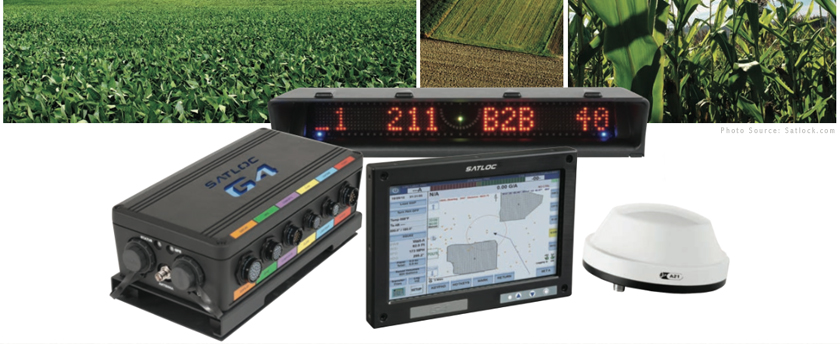
Satloc G4
The Satloc G4™ is the most complete and advanced aerial guidance system for aerial applicators. Satloc G4 is built with the top-of-the-line processing power of Intel® Dual-Core™ i7 processor and includes Windows® 7 64-bit operating system. The Satloc G4 features a new 9-inch, 16:9 ratio touchscreen capable of providing faster video graphics as well as the latest in touchscreen technology. Use multi-touch gestures such as pinch-to-zoom, rotate and press and drag to access information. Experience improved connection speeds for downloading job and shape files and prescription maps. The Satloc G4 features video capabilities including Skype™ and Ethernet connectivity for cell-based modems. Background maps are available with Satloc G4 systems. Maps enhance flight navigation and confidence by allowing aerial applicators to view flight information such as spray, waypoints, and polygons on background maps. Stay connected with HQ™, a real-time web-based asset tracking tool that allows companies to track the position and position-related data of aircraft and other assets, such as spotter vehicles and loader trucks. The Satloc G4 system includes a 9-inch touch screen, CPU, A21™ antenna and external CAN lightbar.
As Applied Maps
Using GPS, Jim's Agri-Air can mark and keep track of swaths in fields with pin-point accuracy. This allows the exact amount of chemical to be applied across the entire field, resulting in accurate and cost-effective applications.